Tour du Mont Blanc, 3rd.-12th. July, 6th.-9th. September 2014
The Tour du Mont Blanc is a walking trail in the French, Italian and Swiss Alps making a 180km circuit of Mont Blanc, normally starting and finishing in Les Houches near Chamonix. The highest point reached by the standard route is 2,584m and the height gain (and therefore loss) around the whole Tour is around 10,600m. Trekkers typically take 11 days to complete the circuit, give or take a day or two.
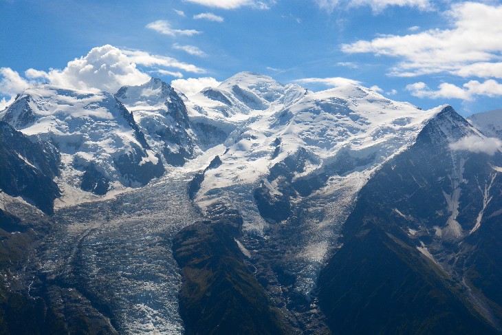
The final stages above the Chamonix valley from Argentiere to Les Houches, are regarded by many as the most enjoyable of the whole tour. With good weather this section reveals the most stunning views of Mont Blanc on the trek, across the deep Arve valley, with the panorama from Le Brevent at 2,525m being particularly impressive. The Italian stages also have especially good views of the Mont Blanc range, and in clear weather the views from Col de la Seine, Tete de la Tronche and Grand Col Ferret are exceptional. Jagged snow and rock peaks are ranged along the skyline here, their glaciers tumbling down to the valleys far below. Other stages on the Tour have their own attractions. For pastoral beauty the relatively easy stage from La Fouly to Champex in the Swiss Val Ferret is hard to beat.
The TMB is for normally fit mountain walkers who are prepared to walk for between 5h and 7h per day along a long-distance trail. One should be used to walks of similar distance and height gain to those to be expected. One long standard stage for many trekkers is the 21km walk from Les Contamines to Les Chapieux. This involves a total ascent of 1,430m to cross the Col de la Croix du Bonhomme at 2,479m. We avoided this by staying overnight at the Refugio Bonhomme splitting the stage in two. The next day we stopped at the Refuge Mottets and could from there reach the Refugio Maison Vieille skipping the often fully booked Refugio Elisabetta. The next-toughest stage was then the walk via Courmayeur to the Rifugio Bonatti. We had not planned any rest days but had a day in reserve for contingencies, which was used in Champex because of the weather conditions.
The TMB is waymarked quite well throughout its length. Waymarks vary between countries, the Swiss signage being the best. The 1:25,000 French IGN maps (2 sheets) are probably the best maps for the whole route. However, it is essential for all parties on the TMB to have at least one competent navigator with a map and compass, for those situations where the route is not marked at a turning or where the clouds have closed in. We were using the Cicerone Guide, ‘Tour of Mont Blanc’ by Kev Reynolds, which invaluable giving a wealth of information for every stage of the tour. The times given here are taken from this guide and are not the times which we actually took ourselves.
Underfoot one experiences a variety of tracks and trails on the TMB. The mountainous sections mostly run on single-track paths that can be rocky in places, sometimes with steps but mostly just the bare earth. Mud is not normally a problem, but we had special conditions! Since many people have travelled a long way to walk the TMB, if it rains, they walk anyway. This turns many of the lower paths into a mud bath after several days of rain. There are three sections on the standard route, all on the stages above the Chamonix valley, where metal ladders have been installed to make the route easier across rocky ground. The hardest two of these sections can be avoided by alternative routes, but none of them should present problems to regular hillwalkers. Tracks are also common – perhaps gravel forest roads, ski pistes, or rough tracks for vehicles over agricultural land. There are some sections of country lanes, of which much the longest is one 4.5km stretch near les Chapieux. We took a small bus for this.
A typical summer’s day in the Alps brings hot sun, perhaps with occasional rain or afternoon storms, but in any case paths that are clear of snow, except for isolated patches on the highest passes. However, fresh snowfalls can occur each summer. Most often, these leave a coating of an inch or two on higher passes only, which disappears in a day or two. See the photos on the Grand Col Ferret.
The TMB’s accommodation is a major attraction of the route and we were able to find a number of interesting places to stay. At various points there are choices of mountain huts, campsites, luxurious hotels, more modest hotels, and auberges with a mix of rooms and dormitories. Most accommodation is family-run, even in the larger places such as Courmayeur. There is a convenient web-site which can be used to reserve accommodation and even to plan the route, since it also gives walking times between the chosen points.
http://www.montourdumontblanc.com
The Tour du Mont Blanc season normally runs from the start of July to the middle of September. Peter, my brother, who came from England, and I planned to make the tour in July since this is the best time to see the alpine flowers, which are profuse in many places along the route. We were joined in the first week by Regina and Margrit, two ladies from the hiking club in Basel, and in the second by Uli who is also a member of this club. We were however very unlucky with the weather. After one or two reasonable days the weather became consistently bad with mist, rain and even snow. We never really saw Mont Blanc. This attempt at the TMB finally came to an abrupt halt in Le Tour near Argentiere in the Chamonix valley, only 2 or 3 days from the finish. We should really have stopped much sooner. Peter was keen though to complete the route and he returned in September, repeating all the route from Courmayeur in fine weather. I joined him where we had broken off in July for the last stages and was rewarded by perfect conditions.